I. The Land Before the Name
The land that became Cumberland County, North Carolina, was inhabited for fourteen thousand years before European settlers arrived and named it. This is not a rhetorical point. It is an archaeological fact established by Stanley Knick’s work at the University of North Carolina at Pembroke, published in 1988, which documented continuous human occupation of the Lumber River and Cape Fear watersheds from the Paleo-Indian period — approximately 12,000 BCE — through the Archaic period (8000–1000 BCE), through the Woodland period (1000 BCE–1600 CE), and into the colonial era and the present.
Fourteen thousand years is not an abstraction. It is 560 generations of people farming, fishing, building, governing, praying, burying their dead, and raising their children on the land where Fayetteville now stands. The Cape Fear River was not named the Cape Fear by the people who lived along it for those fourteen thousand years. The city at the river’s falls was not named Fayetteville by them. The county was not named Cumberland by them. Every name on the map of this region is a colonial overwriting of a prior name — and the prior names represent a prior civilization whose existence the colonial project required to be denied.
The Two Americas archive begins its Prologue with the African cradle of humanity and moves through the African empires that Europe refused to acknowledge. It ends its Prologue here — on the ground where Two Americas readers most directly live — with the acknowledgment that this specific ground had its own civilization, its own governance, its own history, and its own people, for fourteen thousand years before the story the standard curriculum calls “North Carolina history” began.
II. The Five Nations — Who They Were and What They Built
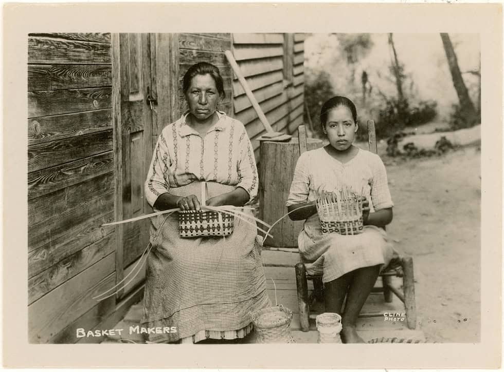
The Lumbee Tribe of North Carolina is the largest Indigenous tribe east of the Mississippi River. The Lumbee people are descended from the convergence, over centuries, of several Indigenous peoples whose distinct tribal communities had occupied the Lumber River basin and the Cape Fear watershed prior to European contact — including Cheraw, Saponi, Hatteras, Tuscarora (Skarure), and Cape Fear peoples. The Lumbee historian Malinda Maynor Lowery has documented this multi-origin convergence as a deliberate act of survival: as colonial pressure reduced the land bases and populations of individual tribal communities, their surviving members came together in the swamplands of the Lumber River, where European access was difficult and where a new, composite identity could be maintained.
The Lumbee have been the most continuously present Indigenous community in what is now southeastern North Carolina. They resisted racial categorization under Jim Crow — classified by the state as neither Black nor white, they occupied a legally ambiguous space that they defended with community solidarity and organized political action. In 1958, the Lumbee confronted and routed a Ku Klux Klan rally held in Robeson County — an act of organized community resistance that became one of the most celebrated moments of Indigenous civil rights in American history. They are the largest tribe east of the Mississippi. On December 18, 2025, after 137 years of petitioning that began in 1888, Congress granted the Lumbee full federal recognition as the 575th federally recognized tribe in the United States.
The Skarure (Tuscarora) Nation occupied the entirety of the Cape Fear basin and the territory running from the coast through present-day Cumberland, Robeson, Sampson, Bladen, and Brunswick counties before European contact. The Skarure were an Iroquoian-speaking people — linguistically and culturally related to the Haudenosaunee Confederacy of the Great Lakes region — who had built a sophisticated agricultural and diplomatic civilization in eastern North Carolina over centuries. John Lawson’s 1709–1710 survey of the Carolina interior documented Skarure villages on the lower Neuse and lower Cape Fear, noting their towns, their agricultural fields, their trade networks, and the sophistication of their governance. The Tuscarora War of 1711–1715 — the subject of P-4 of this Prologue — destroyed the Skarure’s territorial base, killed thousands, enslaved thousands more, and opened the Cape Fear region to plantation settlement. Some Tuscarora moved north and joined the Haudenosaunee Confederacy as its Sixth Nation. Others remained in North Carolina. Their descendants are still here.
The Eastern Band of Cherokee — the Tsalagi — occupied the mountain country of western North Carolina for centuries before European contact. The Cherokee were one of the most politically sophisticated Indigenous nations in North America: a people with a complex clan system, a council governance structure, a diplomatic tradition that engaged European colonial powers on near-equal terms for generations, and — after the development of the Cherokee syllabary by Sequoyah in 1821 — a written language and a literate press. The forced removal known as the Trail of Tears (1838) — in which approximately 16,000 Cherokee were marched west to present-day Oklahoma under military guard, with an estimated 4,000 dying on the march — was one of the most well-documented acts of ethnic cleansing in American history. The Eastern Band of Cherokee remained in the mountains of western North Carolina, their presence protected by a combination of legal maneuver, the leadership of Chief Yonaguska and later William Holland Thomas, and the sheer inaccessibility of the Smoky Mountain terrain. The Eastern Band is federally recognized, maintains the Qualla Boundary as its land base, and is a sovereign nation in the mountains of North Carolina today.
The Catawba Nation occupied the Piedmont of the Carolinas — the river country between the mountains and the coastal plain — for centuries before European contact. The Catawba were skilled farmers, traders, and diplomats who maintained relationships with both colonial governments and neighboring Indigenous nations across a wide territory. The colonial period was catastrophic for the Catawba: European diseases reduced their population from an estimated 5,000–6,000 in 1700 to fewer than 500 by 1826. The Catawba were among the Indigenous peoples who sided with the British colonists during various conflicts with neighboring nations, a diplomatic strategy that provided short-term protection but ultimately could not prevent the loss of their land base. The Catawba Nation is federally recognized and maintains a land base in York County, South Carolina, with significant community presence in the Piedmont Carolinas.
The Cape Fear and Waccamaw Siouan peoples occupied the lower Cape Fear region — present-day New Hanover, Brunswick, Pender, Columbus, and Cumberland counties — before European contact. The “Cape Fear Indians” documented in early colonial records represent multiple Siouan-speaking communities whose territories converged in the lower Cape Fear watershed. The Waccamaw Siouan people, whose territory centered on Lake Waccamaw in Columbus County, maintain state tribal recognition in North Carolina. The Coharie people, whose territory centered on the Coharie Creek drainage in Sampson and Harnett counties, are also state-recognized. These communities were among the most immediately affected by colonial settlement of the Cape Fear region following the Tuscarora War, as their territories were the specific land opened to plantation agriculture by the Skarure’s forced removal.
III. What They Built — The Civilizational Record
The standard American history curriculum frames Indigenous peoples as pre-civilizational: present before history, swept aside by history, occasionally resistant to history, but never quite part of history in the way that European settlement is part of history. This framing is wrong in every particular.
The Indigenous peoples of North Carolina built and maintained civilizations of genuine sophistication for thousands of years before European contact. The archaeological record of the Woodland period in the Cape Fear and Lumber River watersheds documents permanent villages with established agricultural fields, longhouses, council houses, and burial mounds. The trade networks of the Archaic and Woodland periods connected the NC interior to the Atlantic coast, to the Appalachian mountains, and — through the exchange of specific materials like Gulf Coast shells and Appalachian copper — to trade networks extending across the eastern half of the continent.
The Cherokee syllabary — developed by Sequoyah between approximately 1809 and 1821 — was one of the most remarkable intellectual achievements in the history of North America: an independently invented writing system, created by a man who was not himself literate in any European language, which reduced a complex tonal language to a set of eighty-six characters that adult Cherokees could learn to read and write in days. Within months of its introduction in 1821, the majority of the Cherokee Nation was literate. Within years, the Cherokee had a printing press, a bilingual newspaper (Cherokee Phoenix, first published 1828), and a written constitution. This is the civilizational achievement of a people the Indian Removal Act of 1830 classified as “savage.”
The Haudenosaunee Confederacy — the political model to which the Tuscarora’s Skarure predecessors were related — exercised documented influence on the framers of the United States Constitution. The Great Law of Peace (Gayanashagowa), the Haudenosaunee constitution, established principles of representative governance, separation of powers, and impeachment of leaders that Benjamin Franklin and others acknowledged studying. The Iroquois influence on the American constitutional tradition is documented in the historical record and recognized by a 1988 concurrent resolution of the United States Congress, which acknowledged “the confederation of the original 13 colonies into one republic was influenced by the political system developed by the Iroquois Confederacy.”
IV. The Survival — What the Contribution Track Requires to Document
The contribution track of Two Americas documents what was built. In the case of North Carolina’s Indigenous peoples, the most significant contribution of the post-contact period is the fact of survival itself.
The Lumbee survived colonialism, slavery’s attempt to categorize them, Jim Crow’s attempt to erase them, and the federal government’s attempt to terminate their legal existence. They are still here — in Robeson, Hoke, Scotland, and Cumberland counties — the largest Indigenous nation east of the Mississippi, still fighting for full federal recognition, still maintaining community, language memory, and cultural practice.
The Eastern Band of Cherokee survived the Trail of Tears — stayed in the mountains, maintained their land base, maintained their sovereignty, and rebuilt their nation. The Museum of the Cherokee Indian in Cherokee, North Carolina, is one of the finest Indigenous cultural institutions in the United States. The Cherokee language revitalization program at New Kituwah Academy is producing the next generation of fluent speakers.
The Catawba survived population collapse, land loss, and a termination period (1959–1993) during which the federal government unilaterally ended their recognized status — an act reversed by the Catawba Indian Nation Land Claims Settlement Act of 1993, which restored federal recognition and provided a partial land settlement.
The Skarure (Tuscarora) who remained in North Carolina survived the war that bears their name, the enslavement that followed, the dispersal of their community, and the two centuries of colonial and then state policy designed to make them invisible. Their descendants maintain tribal organization and identity in eastern North Carolina.
Survival under these conditions is not passive. It is active, organized, multigenerational, and ongoing. It is a contribution to the human record of the same order as building a university or administering an empire. The people of these nations are still here. That is the contribution this entry documents.
V. Still Here — The Present
The contemporary Indigenous nations of North Carolina are sovereign peoples with active governments, active land claims, active language revitalization programs, active cultural institutions, and active relationships to the federal and state governments that have spent two centuries attempting to reduce, terminate, or ignore their existence.
The Lumbee Tribe of North Carolina is headquartered in Pembroke, Robeson County. The tribe achieved full federal recognition on December 18, 2025, after 137 years of seeking it. Their land base includes Cumberland County — the county where Fayetteville sits. Their history is the history of the ground on which Fayetteville was built.
The Eastern Band of Cherokee Indians is headquartered on the Qualla Boundary in Jackson and Swain counties. They operate Harrah’s Cherokee Casino Resort, the Museum of the Cherokee Indian, and the New Kituwah Academy. They are a federally recognized sovereign nation with a written constitution and an elected principal chief.
The Catawba Indian Nation is headquartered in Rock Hill, South Carolina, with significant community presence in the NC Piedmont. Federally recognized. Active cultural programs.
The Coharie Tribe is state-recognized in Sampson and Harnett counties. The Waccamaw Siouan Tribe is state-recognized in Columbus and Bladen counties. The Haliwa-Saponi Tribe is state-recognized in Halifax and Warren counties. The Meherrin Nation is state-recognized in Hertford County. The Skarure (Tuscarora) Nation of North Carolina maintains tribal organization in eastern NC. Altogether, North Carolina has eight state-recognized tribes in addition to the two federally recognized nations — the Eastern Band of Cherokee and the Catawba. The Lumbee were state-recognized in 1885 and given partial federal recognition under the Lumbee Act of 1956, which explicitly excluded them from the full benefits of federal recognition. That gap closed on December 18, 2025, when Congress granted the tribe full federal recognition as the 575th federally recognized tribe.
They are still here. This is the foundational contribution.
Learn More…NC_Indigenous_Peoples